Where Parishes Butt
Thornie
Added on 05 February 2025
Murthly estate stretches across three parishes – Auchtergaven, Kinclaven and, mostly, Little Dunkeld. Their boundaries meet at a particular point. And I had a pretty good idea as to where that would be. 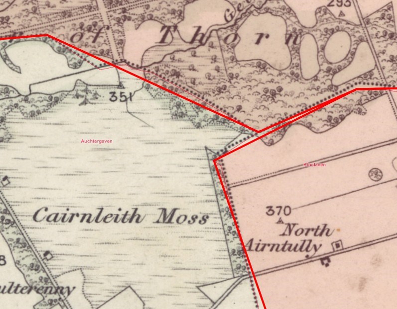
Thanks to the National Library of Scotland’s excellent digital mapping service (www.maps.nls.uk) I was able to mouse my cursor over the exact spot on an old OS map and read off both grid ref (NO086370) and gps co-ordinates (56 31 00 N, 3 29 09 W). It was the work of minutes to transfer these to my OS 1:25000 and Garmin. There can’t be many estates where three parishes meet: Would anyone have troubled to mark the spot?
I didn’t bother asking Moss “Shall we find out?”, just reached for my boots, and she was boing boing like Zebedee at the back door.
The place we were heading for is less than two miles away. As satellites fly. But as ground pounders we would take several tracks and make four right angled turns. One of the tracks follows the route of the pre-turnpike Dunkeld to Perth Road that passed through Douglasfield (Home Farm) heading towards Airntully. Another turn and we were on a track parallel to Stewart Tower Road, leading to the Drum Strip. When you get there a short digression through the trees will bring you to the edge of Cairnleith Moss, which falls away southwest to the A9, and you’ll realise you have been walking up onto a ridge. Hence the name: Drum/Druim (Scots Gaelic for ‘ridge’).
One more turn takes us past the site of Drumm of Airntully, formerly a small farm of just 78 acres (14 arable; 64 pasture) but so thoroughly ‘improved’ there are only a few hummocks to indicate it ever existed. It was mapped and recorded on the folio of estate plans hand-drawn by James Chalmers for Sir George Stewart in 1825. Made the 1st edition OS map of 1865 (but lost an ‘m’ along the way) and was dropped altogether by the 2nd edition, revised in 1889. Sir George’s second son, William (1795 – 1871) continued his father’s agricultural improvements across the estates, amalgamating farms into bigger (for the time) units. Drum is/was a bit out of the way. A more obvious example of Sir William’s work can be seen at Pittensorn farm, which now stands alone having swallowed two others, Hillhead and Tathyhill.
My Garmin wasn’t beeping yet, but I could see we were closing in on the spot. The land to the north and east of Drumm of Airntully was given over to plantations of trees even earlier than 1825 when they were mapped. The Harris family who farmed there for generations would have had a solid wall of green obscuring, if not entirely blocking their view of Birnam Hill. A lot of timber has been extracted recently, and a new gate marks the start of the soon to be wooded anew area. Moss dashed over to investigate a large cardboard boxed strapped to a pallet that had been delivered just inside the gate. A medley of seeds and saplings addressed to Scottish Woodlands. Precisely delivered to a what3words location.
I was beginning to fret now as I had my own green wall to deal with: thickets of gorse with a covering of blown over conifers. There’s never a Stihl saw when you need it. Aye, ah ken a boy who has yin (who disnae) . . . back in the village. What to do here. Now. Sos, Lady Serendipity, muse of local historians and responsible for so many of my discoveries, whispered ‘Walk away’. Which made sense. Early on you learn not to slavishly follow the arrow on the Garmin screen. It zeroes on co-ords and knows nothing of terrain. That arrow will walk you off a cliff . . .
Or, in this case, off the edge of a ha-ha. Ok, only three feet or so into a sunken ditch. More of an embarrassment than life threatening, but not a good look.
So, walk away. Step back; get the bigger picture. It looked like the end point might be off to the left, other side of the gorse. Not entirely clear of the windblow, but still . . . achievable. And with some crouching and stepping over, backing up and going around (while Moss kept well back, looking puzzled) I was there.
The point where Auchtergaven, Kinclaven and Little Dunkeld butt-up is marked. With a simple iron corner post, set securely into stone. On the edge of the Keepers Long Field, where the ha-ha has been bellied into a curve to meet it. 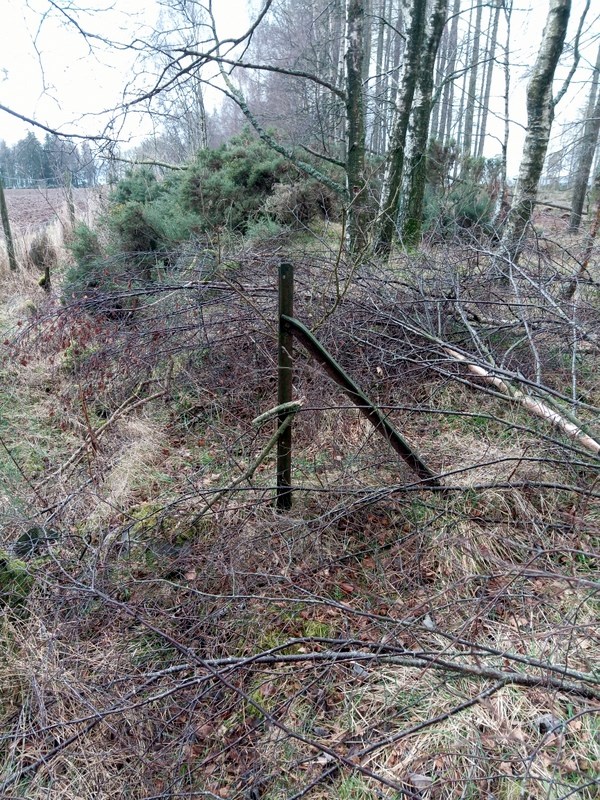
Who by? Quien sabe. For as I often must admit . . . there are gaps in the record.